
EARTH OBSERVATION TECHNOLOGY (EOT) APPLIED TO ARCHAEOLOGICAL HERITAGE AND GEORESOURCES PROTECTION
Climate action - Life below water
For achieving the objectives
Agenda 2030

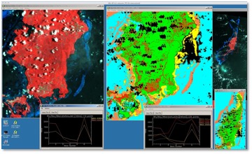
ENEA’s expertise is put at disposal for image processing and radar and optical images classification procedures applied to the study of local phenomena for the management and protection of archaeological heritage, natural resources (surface and phreatic water, land use) and emergencies (earthquakes, floods, historical centres vulnerability).
Satellite multispectral data processing through the analysis of the related forms and processes allows to produce thematic cartographies for the rational management of the landscape.
Benefits and advantages
- Landscape scenarios for planning
- Response to emergencies
- Capacity building
- Creation of economic activities;
ENEA Service
- design
- technology transfer
- training
ENEA Activities
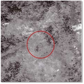
- “Progetto geoarcheologico congiunto Govi-Altayn" (i.e., joint geoarchaeological project Govi-Altayn) in Mongolia (http://www.arch3.eu/siti/mongolia/pages/progetto.html)
- Cooperation programmes with Small Island Developing States (SIDS) in the Palau Islands archipelago under the ENEA-MATTM cooperation agreement
- “Strengthening Protected Area Management in the Kingdom of Tonga”
- A national marine spatial plan for Vanuatu – including a network of marine protected areas
Keywords: Remote sensing, georesources, territorial processes, territorial planning
|
|
References
Territorial and Production Systems Sustainability Department