
Environment: New Italian technologies for coastline mapping
1/7/2021
From a joint ENEA-ISPRA-CNR-IUSS project new remote observation technologies for coastal management.
Case study, a stretch of the Lazio coast
 Innovative remote observation technologies will make it possible to study beaches and sea beds to mitigate the effects of coastal erosion and improve tourist accomodation. These are the outcomes of a research conducted by a multidisciplinary team of ENEA, ISPRA, CNR and IUSS researchers on a stretch of the coast of the Circeo National Park between Latina and Sabaudia, Lazio. The studies, published in the international journal Remote Sensing are based on a new technique that combines remote sensing techniques with high resolution aerial sensors (LiDAR - Light Detection and Ranging) and in situ measurements for the calibration and verification of the acquired data.
"LiDAR enabled us to have a view of the seabed at a depth 18 meters and identify the stretches where sand bars can feed the emerged beach and mitigate the effects of coastal erosion, with a considerable applicative impact on the sea economy. Furthermore, these technologies allow to assess and monitor the effectiveness and sustainability of these intervention strategies", explained Sergio Cappucci, ENEA researcher at the Laboratory of Technologies for Structural Dynamics and Prevention of Seismic and Hydrogeological Risk.
Sand bars are natural accumulations formed mainly in shallow sandy bottoms due to the motion of currents and waves. So far, on the basis of accredited literature [1], eight types, with different shapes and sizes, have been identified.
In order to study the beaches and natural formations, the researchers processed a large amount of data detected by airborne and ground-mounted sensors, using a method developed by the team. It is called FHyL[2] and optimizes the integration of geophysical and ecological knowledge with that of automation and artificial intelligence technologies. The result obtained from the application of the FHyL method was a 'high resolution photograph' of the coast, where the most at-risk stretches on which to intervene were identified.
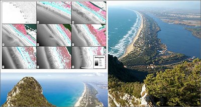
- Panoramic view of the coastline and the submerged bar system. Image of the Circeo National Park.
That’s why this project is very likely to be widely applied on many Italian coastal areas at risk of erosion ”, Cappucci said.
"Geospatial data analysis - performed with software G.I.S. (Geographic Information System) - allow to characterize and study larger stretches of coastline and compare the variation of the detected bottom shapes, caused by different weather, sea and hydrodynamic conditions. In this way, we are able to reduce time and costs compared to surveys conducted with traditional methods ”, pointed out Lorenzo Rossi and Iolanda Lisi, researchers at ISPRA.
For Emiliana Valentini of the CNR, "the overall view of the submerged and emerged beaches is the real opportunity that these remote surveys offer us. The study highlighted the structural and functional complementarity of the submerged sandy bars, the beach and the dunes, allowing an assessment of the ability of this stretch of coast to respond to the risk of erosion ”.
"Italy is the only European country to have invested massively in the use of data and operational services based on aerial and satellite surveys for the analysis of the territory through the Copernicus Mirror. In fact, the economic impact of the surveys and analyses of the data examined in this study appears promising also for the reduction of the costs of environmental monitoring and control ", Andrea Taramelli of the University School for Advanced Studies of Pavia (IUSS) and national delegate Copernicus of the Presidency of the Council of Ministers to the European Union.

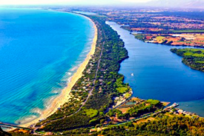
- A stretch of shallow water examined. The submerged bar system is highlighted (the position of the ridges is indicated with a blue and red line).

- Graphical abstract of the study. Above, the elaborations that made it possible to classify the sandbars and two images showing the coast in calm and rough sea conditions (note the breaking effect of the waves). Image of the Circeo National Park 8
Graphical abstract of the study. Above, the elaborations that made it possible to classify the sandbars and two images showing the coast in calm and rough sea conditions (note the breaking effect of the waves). Image of the Circeo National Park 8 (photo caption3)
For more information please contact:
Sergio Cappucci – ENEA, Sustainability of Productive and Territorial Systems Department - sergio.cappucci@enea.it
Andrea Taramelli – IUSS and ISPRA - andrea.taramelli@iuss.it; andrea.taramelli@isprambiente.it
Emiliana Valentini – CNR - emiliana.valentini@cnr.it
Published Article:
https://www.mdpi.com/2072-4292/12/7/1053
TARAMELLI A., CAPPUCCI S., VALENTINI E., ROSSI L., LISI I. (2020). Nearshore Sandbar Classification of Sabaudia (Italy) with LiDAR Data: The FHyL Approach. Remote sensing. Remote sensing, 12, 1053; doi:10.3390/rs12071053
Video
Video of the coastal dunes of the Circeo National Park shot with drones
Interventions conducted to widen the beach taking sand from the submerged sandbar
[1] In this regard, we cite the works of Short (1999), Handbook of Beach and Shoreface Morphodynamics, and Van Rijn (1998), Principles of Coastal Morphology; Aqua Publications, as an example of compendia of studies of the fundamental principles for the study of the spatial and temporal variability of sand bars morphology and their impact on the dynamics of the beach system.
[2] Field spectral libraries, airborne Hyperspectral images and LiDAR altimetry (https://ieeexplore.ieee.org/document/6723270)