
Environment: project Geoswim to survey 23,000 kilometres of Mediterranean coast
22/9/2016
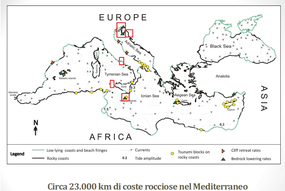
Mapping the rocky shores of the Mediterranean for a total of 23,000 kilometres to investigate the mechanisms of coastal erosion through changes in the sea level is the objective of the research project Geoswim, coordinated by the University of Trieste in collaboration with ENEA and whose first expedition in 2016 was in the Conero, Marche.
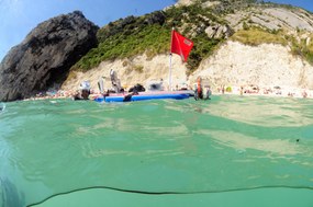
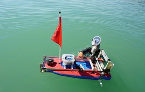
The specificity of the project is the fact that the team of researchers worked underwater, with masks and fins, swimming for kilometers towing a small laboratory called Ciclope, equipped with cameras, a sonar and probes to record the changes in the physical-chemical composition of the water.
“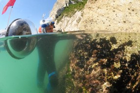 By closely observing the coast, inch by inch, just below water level- Fabrizio Antonioli, ENEA geomorphologist, pointed out – we can observe what satellites and boats cannot detect. We are therefore able to continuosly monitor coastal variations, study the mechanisms of coastal erosion and formation of marine caves and the presence of freshwater springs. This information enables us to determine recent sea-level variations”
“Geoswim- Antonioli added- has started four years ago with an ambitious goal: mapping the whole rocky coast of the Mediterranean, swim-surveying both the European and the African shores, crossing Turkey and the Middle East. Until then only a few rocky bitts of the Mediterranean had been studied.
 The project focuses also on the study of the fauna and flora, such as molluscs, barnacles and balanoides that live attached to rocks but also plants and algae, with the aim of collecting data on the environmental conditions, the presence of freshwater and the eroding action of waves.
“The surveys - Stefano Furlani, geomorphologist at the University of Trieste, Responsible of the project Geoswim, explained - consist mainly in the observation and mapping of coastal forms, such as caves, potholes, notches, in addition to collecting data on temperature and conducibility. All data is georeferenced, that is to say related to specific geographic coordinates”.
The Conero expedition, that has investigated the strech of the Adriatic between Portonovo and Sirolo, in the Ancona Province, has seen the participation in the research team of the University of Urbino and the Rome University “La Sapienza”.
 “We have identified –Furlani went on - the cracks along the coast and the stacks called Le due Sorelle, one of the symbols of the Conero, important indicators telling the centennial history of this place through earth-crust movements and sea-level variations.
“In the last three hundred years – Antonioli added – large rock slides have occurred in the Conero Ridge. In fact our surveys have shown a reduced presence of marine organisms along the plunging cliffs due to masses of unstable rocks and the high energy of waves. The surveys have shown a general tectonic stability of the whole Ridge. We also detected an alga, Ulva Lactuca, also known as sea lettuce, marker of the presence of freshwater springs in the sea.
After the first expedition in 2012, in which 250 kms of coast were investigated from Sissano, Istria, to Trieste, Geoswim has continued to Malta, Sicily (Egadi and Ustica), Sardinia (some islands in the Archipelago of La Maddalena, Capo Caccia and Tavolara) and Lazio ( Gaeta), swimming for a total of 600 kilometres. Next stop will be Greece.
For more information:
Fabrizio Antonioli – ENEA, Climate Modelling Laboratory – Division of Models and Technologies for the Reduction of the Anthropic Impacts and Natural Risks – Department of Sustainability of the Productive and Territorial Systems – fabrizio.antonioli@enea.it